


FILES
1. Product Description
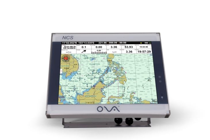
AIS for boats with 15” display marine plotter is supplied by SAIYANG Electronics.
We are professional class b ais equipment manufacturer, and our gps marine navigation could support S57 and C-Map chart format.
Specification
| Model | AIS-N15 |
| Display | 15” |
| Resolution | 1024*768px |
| Voltage | DC 24V(11~35V) |
| Power | High-performance, full isolated, PWM control of power supply |
| Mount | Bracket Mount or Flush Mount |
| Power Consumption | ≤20W |
| Language | Simple Chinese, Traditional Chinese, English (Can be customized) |
| Map Format | S57, S63(ENG), CJ57, CJ63, C-Map |
| Image Format | img, tif |
| Map Display Mode | Heading Up, Course Up, Route Up, North Up, East Up, South Up, West Up |
| Ownship Data | Position, Speed, Course, Heading, Altitude, GPS Positioning Status, Present Fishing Zone |
| Navigation Data | Bearing, Present Distance, Distance to the Destination, Yaw Distance, Yaw Angle, Navigation Arrow, Sailing Time, ETA (Estimated Time of Arrival), Navigation Distance, Average Speed, Maximum Speed, Target Fishing Zone, etc. |
| Others | Time, Depth, Wind Speed, Wind Direction, Simple Compass, etc. |
| Data Display Mode | Top Display (Various Arrangement), Left Display, Right Display, Suspension Display |
| User Data | ≥50000 waypoints, 200 routes, 10000 waypoints per route. 20000 tracks, 500 tracks per AIS. Plot data(point, line, plane) |
| SD Card | Update Software, chart data import and export |
| AIS Functions | AIS Display, AIS Message, AIS Log, AIS Fleet Management, AIS Fishing Net Management, AIS Special Vessel Management. etc. |
| System Alarm | Loss Alarm, Time Alarm, Low Voltage Alarm, High Voltage Alarm, No Positioning Alarm, Positioning Accuracy Alarm |
| Navigational Alarm | Yaw Alarm, Arrival Alarm, Anchor Drag Alarm, Bridge Alarm, Danger Alarm, Precautionary Area Alarm, etc. |
| Other Functions | Measuring Distance, Compass Superposition, Eccentric Setting, Calendar, Harbor, Tide, Odometer, Navigational Log, Find the Map according to Longitude and latitude, etc. |
| GNSS Performance | Customized Positioning Source(GPS, Beidou, Glonass, Galileo) |
| Receiving Type | GPS, Beidou, Glonass, Galileo |
| Receiving Channel | GPS:1575.42MHz Beidou:1561.098MHz |
| Positioning Time | Cold Start:45s
Hot Start:15s |
| Positioning Accuracy | GPS:<15m (95%)
Beidou: Horizontal 25m (95%) Vertical: 30m (95%) |
| Input(NMEA0183) | GPS, AIS, Compass, Depth, Water Temperature, etc. |
| Output(NMEA0183) | GPS: GGA, GLL, GSA, GSV, RMC, VTG, ZDA |
| Navigation | AAM, APB, BOD, BWC, BWR, RMB, RTE, WPL, XTE |
| Sonar | DBT, DPT, MTW, VLW, VHW |
| USB | Software Upgrade; Can be connected with Mouse, Keyboard; User data import and export |
| Frequency | AIS 1: 87B/161.975MHz
AIS 2: 88B/162.025MHz |
| Bandwidth | 25KHz |
| Output Power | 2W |
| Modulation Mode | GMSK |