


FILES
Product Description
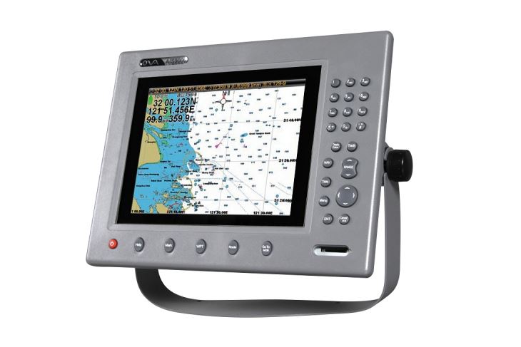
GPS marine navigator AIS9000-10 is built-in AIS function supplied by Nantong Saiyang Electronics Co., Ltd.
Under the GPS function,you can see your onw ship position and target position clearly.
Product Feature
- Ø Powerful and Advanced Technology
GPS, Chart, Tide, Compass, etc.
Built-in AIS Collision Avoidance Navigation System
Can connect with ultrasonic echo sounder, fish finder and work with net sounder
Quick flash start technology
- Ø Flexible and Convenient Operation
T9 digital keyboard, supporting Chinese Input
With Garmin Operating Style
- Ø Certified with authoritative quality system
Comply to ISO9001:2008 International Quality System certified by CCS
According to AIS Class B shipborne Equipment Standard (IEC62287-1)
Comply to NMEA0183 Standard with RS422/RS232 Interface
- Ø External and Quick Update
Rapidly update by external SD card that is fully supported the system, chart, and the update of the extended function.
- Ø Industrial and High Quality Material
Professional true-color TFT LCD, suitable in the sun and at night
Independent research and development of GPS receiver board, accurate positioning, stable navigation speed and course
- Ø Exquisite Appearance, Convenient and Practical
Professional design, supporting the embedded installation,
Exquisite, fashion and firm.
Product Specification
| Model | AIS9000-10 | |
| Display Size | 10″ | |
| Resolution | 640×480 | |
| ExternalDimension | 372.6mmx283.3mmx97.1mm | |
| Display Mode | TFT LCD COLOR Display | |
| Operating Mode | Adjustable backlight button, shortcut button, T9 keyboard | |
| Language | Simple Chinese, English, Traditional Chinese | |
| Voltage Range | 11~35V DC | |
| Power | High Performance, full isolated PWM control of power supply | |
| Power Dissipation | ≤20W | |
| Safe Distance of Compass | ≥1.5m | |
|
AIS Function |
TX Channel | 1 ch |
| RX Channel | 2 ch | |
| Frequency | 156.025~162.025MHz | |
| Receive Frequency | 156.025-162.025MHz | |
| Default Channel | CH2087,CH2088 | |
| Bandwidth | 25KHz | |
| Modulation Mode | GMSK | |
| Receive
Sensitivity |
Superior to-107dBm | |
| TX Channel | 87B/161.975MHz | |
| RX Channel | 88B/162.025MHz | |
|
GPS Receiver |
Adopt high speed stable technology | |
| GPS positioning accuracy:≤15m, 95% accuracy | ||
| Positioning time:cold start 45s, warm start 15s | ||
|
Navigation Performance |
Waypoints & Marks:6000 waypoints | |
| Route:200 routes, each route contains 99 waypoints | ||
| Track:≥200routes | ||
| Include the tide and compass | ||
| Intelligent collision avoidance | ||
|
Interface |
1.GPS Output:RS-422, NMEA0183, 4800bps | |
| 2.AIS Input & Output:RS-422, NMEA0183, 38400bps | ||
| 3.Sonar Input & Output:RS-422, NMEA0183, 115200bps | ||
| 4.GPS Antenna Interface:BNC base, impedence, 50Ω | ||
| 5.VHF Antenna Interface:UHF base, impedence, 50Ω | ||
| 6.PowerInterface:24V DC (11~35V DC) | ||
| Environment | Temperature | -15℃~50℃ |
| Protection Level | IP44 | |
|
Standard Annex |
1. GPS Antenna | |
| 2. Power Line | ||
| 3. Safety Fuse, Locking Screws | ||
| 4. Manual, Certificate, Warranty Card | ||