


FILES
FURUNO GP-150 is a GPS navigator designed for the SOLAS ships according to the GPS performance standard IMO Res MSC.112(73) and associated IEC standards effective on and after July 1, 2003. It is a highly reliable standalone EPFS (electronic position fixing system) that feeds positioning information to AIS, Radar, VDR, VideoPlotter, Autopilot, Echo Sounder and Sonar.
Receiver dependability is improved by fault detection using five satellites, i.e., Receiver Autonomous Integrity Monitoring (RAIM) that shows the integrity status in Safe, Caution, and Unsafe levels. The status is given with respect to the user-selected accuracy level, 10 m or 100 m. RAIM also works on DGPS signals.
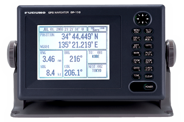
The GP-150 consists of an antenna and display unit. The display unit is a 6″ silver bright LCD, offering optimum viewing around the clock. In order to improve position accuracy, WAAS and DGPS* augmentation systems are available. Dual configuration, with a second system, provides a backup and/or remote operation to ensure system availability.
*Internal or external beacon receiver is required for utilizing DGPS.
Key Features
- Fully meets new IMO Resolution MSC.112(73) and IEC 61108-1 Ed.2 for SOLAS carriage requirements on and after 1 July 2003
- Ideal sensor of SOG and COG for AIS, radars, and other navigational aids Augmentation to enhance accuracy by standard fitted WAAS and optional DGPS
- Display modes: VideoPlotter, 3-D Highway, Text, Steering.
- Memory: 2,000 points for ship’s past positions and marks (incl. 99 event marks max.); 999 waypoints; 30 routes each containing up to 30 waypoints
Display mode is selectable from VideoPlotter, Text, Highway and Steering. In the Highway mode, you can intuitively see how to steer and where the next waypoint is located relative to your ship. It is useful when you are following a series of waypoints along a planned route.
| GPS | |
| Receiver | 12 discrete channels all-in-view, C/A code |
| RX Frequency | L1 (1575.42 MHz) |
| Time to First Fix | 12 s (Warm start) |
| Tracking Velocity | 900 kt |
| Geodetic System | WGS-84 (NAD-27 or others selectable) |
| Update Rate | 1 s |
| DGPS | |
| Reference Station | Automatic or manual selection |
| Frequency Range | 283.5 – 325.0 kHz (all ITU regions) |
| Format | RTCM SC-104 Ver 2.0 Type1, 7, 9, 16 |
| WAAS | WAAS augmentation is available through the GPS core in the display unit |
| Accuracy | |
| GPS | 10 m (95%) |
| DGPS | 5 m (95%) |
| WAAS | 3 m (95%), limited coverage |
| SOG | ±0.2 kt (SOG ≦ 10 kt) |
| COG | ±3° (SOG 1-17 kt), ±1° (SOG > 17 kt) |
| Display | 6″ LCD (120 x 91 mm), 320 (H) x 240 (V) pixels, |
| L/L resolution | 0.001 min |
| Display Modes | VideoPlotter, Highway, Text, Steering |
| VideoPlotter Scale | 0.02 to 320.0 nm, |
| Plot Interval | 1 s – 60 min or 0.01-99.99 nm |